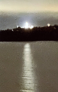
Nauvoo, Illinois, at 2:00am; I am a member of the Church of Jesus Christ of Latter-day Saints, and I did SO want to see Nauvoo and hopefully the Nauvoo Temple. I was blessed to be on the correct side of the ship and to wake up just in time to see the shining lights of the Nauvoo Temple. One of the small “warm fuzzies” that happened on this wonderful trip.
I naively imagined that there would be towns or cities or ports or LIGHTS all along the river. Not so at all. Since Mother Nature is in control of the meandering Mississippi, the channels are like braided ribbons, miles wide. Because of this, nothing permanent is built right on the river’s banks. Made sense. So it was pitch-black-dark at night most of the way. (Except when, above St. Louis, we would enter a lock at night and everything was brightly lighted.)
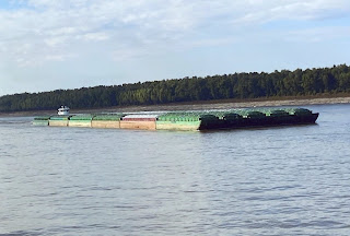
The Mississippi flows just under 1800 miles from St. Paul to New Orleans, and falls 450’ in elevation from St. Paul to St. Louis; the 28 locks and dams on the upper river (above St. Louis) were constructed to control the river and keep the water where farmers needed and wanted it. Most of the locks are quite shallow, under 11’. Exception is the one at Keokuk at 38’. Some 60% of American exported grain comes down the Mississippi. One barge can carry more than 70 trucks or 16 train cars; by water is the most efficient way to ship grain. In October 2022, we saw barges half empty so as to rise higher above the bottom and not get stuck.
The Mississippi is really many rivers in one. First part is the headwaters above St. Paul; no boats allowed on this part. Next is the St. Paul to St. Louis, with those 28 dams and locks. Third is St. Louis to Cairo (KAY-row); fourth is Cairo to Baton Rouge. Last is the Baton Rouge to New Orleans section of the river. Our teacher that day characterized the lower Mississippi as a “huge parking lot of ships and barges with a stream running through it.”
Those states having boundaries along the Mississippi have seen their boundaries changed over the years due to three factors: (1) Mother Nature, ribboning the river all across the miles wide area between the hills; (2) Corps of Engineers working since 1824 to control the river and straighten out crooked or tight bends; (3) Civil War.
More Jeopardy fodder for you, no?
Donna, I have enjoyed your trip down the Mississippi.
I have visited both Nauvoo and Keokuk and just hadn’t thought to see how close they were to the Mississippi, or learn more of the river while there…that is a real shame to have missed the opportunity. Thanks for your information!