Let’s Talk About: Benge, Washington


Benge, Washington, with a 2000 population of 57 souls, is in Adams County. The famous Mullan Road, built to connect the Missouri River with the Columbia River, passed through Benge…..that portion was finished in May 1861. Still in 2008, the wagon ruts from the Mullan Road could be seen.

The road was built as a military road, but civilians and travelers alike used the road until the Northern Pacific Railroad was completed in 1883. 

The town was named for Frank H. Benge, who, with his family, was an early settler. He represented Adams County in the State Legislature in 1904 and he donated the land to found the town. 

Here’s a very early picture of Benge, Washington. Anybody have relatives or ancestors who lived in this Adams County farming town???

Let’s Talk About…Mississippi River’s Worst Disasters

The New Madrid Earthquake of 1811  —  The area known as New Madrid was, in 1811, a ways upriver and was sparsely populated. After the Revolution, people were flocking west, crossing the Appalachian Mountains, but blessedly there were few settlers in the New Madrid area in 1811.  So what happened?

On 16 December 1811, at 2:15 am, not one but THREE magnitude 8.0 or higher shook the area in that one day. In January 1812, there was another big shake, followed in February by a last 8.8 shock. Church bells rang as far away as Charleston, South Carolina, and Boston. These four big quakes in a three month period happened because “a seam between two plates pulled apart,” explained our presenter. “And the quakes continue to today…. There have been 4000 quakes recorded since 1974! And if and when another big one comes, the entire Midwest will be in big trouble,” he mused.

The Sultana disaster of 1865  —  In the early morning hours of 27 April 1865, mere days after the end of the Civil War, the side-wheeled steamboat Sultana burst into flames, taking 1169 people….mostly Union soldiers (newly freed from Anderson Prison in Georgia) returning home. This was the worst maritime disaster in U.S. history.  So what happened?

The ragged band of paroled Union soldiers was taken by train from Andersonville to Vicksburg, Mississippi. There, the steamboat Sultana was to take them north and home. The Sultana was moored there in Vicksburg needing to replace a faulty/leaking boiler. The captain was offered a bounty (bribe!) for each man he would take upriver so he ordered the ailing boiler to be patched up and loaded up the men. Built to take 375 passengers and crew, the wooden Sultana had regularly ferried cotton between St.Louis and New Orleans; she was only two years old. The greedy captain (sorry, called it what it was) loaded nearly 2130 souls on board and pushed off into the river. (1953 freed prisoners, 22 guards, 70 fare-paying passengers and 85 crew.) The Sultana spent two days pushing upriver against the worst spring floods in the river’s history.  At around 2:00am on 27 April 1865, when the ship was about seven miles north of Memphis, three of its four boilers suddenly exploded. (If you want to read all the grizzly details click to Wikipedia.) All in all, some 1169 people perished that dark night. “Greed killed them all,” our presenter opined. “And no charges were ever filed against anyone.”

The Flood of 1927  —  The third worst disaster was the Flood of 1927.  Aaron taught us: “That year, we learned the hard way that men had to live with the Mississippi River on her terms. The river drains 40% of the American heartland and as many smaller rivers flow into the Mississippi, the river becomes like a great big funnel and that year, 1927, after heavy spring rains, the “funnel” opened flooding 27,000 square miles.” This was the most destructive river flood in U.S. history. All those miles of land were inundated up to 30 FEET deep over the course of several months in early 1927. About 500 people died and over 630,000 were directly affected. Some 200,000 African Americans were hit hardest; they were poor and unable to pick up and leave in contrast with the “richer white folks” many of whom could and did pick up and leave. 

Levees along the Mississippi were recognized as needed by the 1820s and work was begun to construct them. Long story short, in the early years they were not properly constructed and continually were breached or broken by the tremendously rushing flood waters. Floods still happen today despite much better engineering.  

Any of you, dear readers, have an ancestor who was involved or impacted by one of these disasters?

Let’s Talk About…Duff Green & His Mansion


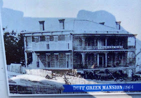
Duff Green, 1791-1875, was an American teacher, military leader, Democratic party politician, journalist, author, diplomat and industrialist…….. and he lived in Vicksburg. He made a good part of his fortune as a cotton broker. He was sympathetic to the Confederate cause but was a realist…………

I quite love to learn the story-behind-the-story, especially in American history, and the story of Duff Green’s mansion is one such story.  The above photos show it as it is today and was during the Civil War.  

Duff Green built his mansion in 1856 high on a bluff using skilled enslaved labor and bricks that were fired onsite. The grand home survived the Siege of Vicksburg because Green designated it a “hospital” where both Confederate and Union soldiers were treated. 

Our tour guide in this mansion was the current owner and her love of this old house was evident. This red-walled photo was of the dining room where dinner was a 6-13 course affair with “libations” served with each course. After dinner there would be a ball with very strict man-woman protocol. “Ladies might wear out their slippers dancing,” she said.  And there is old Duff Green himself; he sired six children with two wives. 

What I’d ask you to imagine here, as I did while there, is this:  It’s summer and temps are nearing 100o. You’re dressed in this huge tight-busted-many-petticoats-and-skirts outfit going to dinner at the Green mansion. The windows are open (it’s HOT) and so there are bugs flying everywhere. The “necessary” (outhouse) was way out back of the house….and here you are in your voluminous garb. You must sit and smile for hours as your fellow guests chew their way through up to 13 courses with different “libations” served with each. And then you’ll dance for hours in that HOT room. No wonder they each wore gloves…… my hands would have been plenty sweaty. 

Now doesn’t that just sound fun??????

Let’s Talk About…American Frontier Expansion

The time: during the period between the Revolution and the Civil War.  Cruise-history-presenter, Aaron, shared his insights on this part of American history.

What was the political reality of the world at that time? Only a handful of men ruled the entire of Europe. These kings had the absolute right to claim entire continents in their name…. or explorers would claim it in their name. This is hard to comprehend today.  France claimed and owned the entire Mississippi River basin. England had the entire of New England. Spain claimed and owned most of the southwest and Florida. Men could not just legally settle anywhere they wanted (squatters exempted).

The stage was set for a civil war when Plymouth and Jamestown were first settled, due to the inherent differences in the men. (The book Albion’s Seed explains this beautifully.)  It took the settlers of Jamestown a long while to realize that they needed to focus on staying alive; forget about finding gold; they had to work, and work together, to stay alive even though they were “gentlemen” and this did not come easy for them.  Biggest problem with Williamsburg, was the old monarchial system into which Williamsburg fell, unfortunately. It was way too top heavy with gentlemen and rulers and not enough workers. Finally all settlements realized that survival tops heredity.

After the Revolution, and as the population increased and begin to spread westward, the biggest draw was water; towns began where there was water. Once in a spot, the settlers began clearing the land for crops; this was all important for survival. A place to live was secondary and the earliest of homes were dirt-floored-leaky-roofed-tiny huts. As the men began to cut down trees for land clearing, for homes and fences, they realized that the very biggest trees were nearly impossible for them to handle. So these giants were just girdled and left to die or felled and burned. Trees of most other sizes were used. Of course a number one building was the outhouse. In the beginning, both family and animals lived in one dwelling; soon barns began to spring up.

Eventually the first tiny structure was added onto, and added on to again and again. This is how many of our ancestors did it, started small and worked up to a decent home in fifteen years.  A fireplace was added as soon as possible, followed by a porch where most of the daily activities took place. Many of the historic homes still today show the evidence of this building-step-by-step.

Aaron, the presenter, went into more details and the where-when-why-hows of frontier settlements but overall he emphasized that “America was settled step by step…California became a state in 1850 only due to gold but there was a big empty gap in the middle, just waiting.”

P.S. I 100% recommend Albion’s Seed as the best book on understanding English emigation to America that you will ever read. Or listen to. Donna

Let’s Talk About….People Stories

Nearing the end of our 14-day cruise, the fellow that had been presenting talks on Mississippi River and American History talks, gave a genealogy talk (and he was good). Afterwards, he invited us in the audience to share our genealogy stories. I was stuck by the enormous variety!

I told my Mathew Potter and the Chicken story….. to howls of laughter. 

Mr/Mrs Bodmer told how they hoped to find the connection between them and the famous Western American painter, Carl Bodmer, but hadn’t yet.

One great-great-grandfather came from Germany, landed in New Orleans, and WALKED up to Wisconsin to live out his life.

One Vietnam veteran told how he flew P3s (submarine hunters) during his Navy career.

One lady told of her sailor, born in the Pyrenees,  who jumped ship in New Orleans, went to Texas with his native wife. When he died, she married another Texas rancher.

One man told how his great-grandfather hid his Comanche wife from the census taker. Can only guess what his reasons were.

“We’ve been in American for fourteen generations, since 1636,” one man boasted.

This was, to me, the saddest story:  A Jewish couple told how her Jewish ancestors were living kosher in San Francisco until the 1906 earthquake when they lost everything, business, home and synagogue, everything.  All the Army had to feed people with was pork and beans. “That must have been so very hard for them,” she said.

This quite proves that everybody with ancestors (!!!!) has a good story.

Let’s Talk About….Mississippi River Locks & Dams

Without dams and locks the Mississippi River would be un-navigable to ships and barges and the states along the river would be continually flooded and their boundaries changed by the meandering river.  Locks and dams are vital to travel and commerce on the Mississippi.


There are 28 locks between St. Paul and St. Louis; there are none below St. Louis. The Mississippi River falls 450-feet between those two cities. Most locks are really shallow, under eleven feet. The largest/deepest lock is at Keokuk, Iowa and is 38-feet deep. (The Mississippi is not a very deep river.) 


The top photo (from Google) shows a dam and lock. As we approached a lock during the night (and this was often the case above St.Louis), the area was flooded with light for navigating into these narrow channels. This maneuver takes knowledge and skill.  The ship enters; the gates behind the ship close; the area fills with river water and when the ship is raised or lowered to the desired level, the front gate is open and the ship proceeds. Not just ships but these HUGE barges too. All us passengers stood on deck (during the day) and watched; it was fascinating. 


The lower photo shows how close we were to the lock walls….that’s my hand reaching out. Illegally, as I found out later. 

Let’s Talk About…Mississippi Shores & Barges


Nauvoo, Illinois, at 2:00am; I am a member of the Church of Jesus Christ of Latter-day Saints, and I did SO want to see Nauvoo and hopefully the Nauvoo Temple. I was blessed to be on the correct side of the ship and to wake up just in time to see the shining lights of the Nauvoo Templ
e. One of the small “warm fuzzies” that happened on this wonderful trip.

I naively imagined that there would be towns or cities or ports or LIGHTS all along the river. Not so at all. Since Mother Nature is in control of the meandering Mississippi, the channels are like braided ribbons, miles wide. Because of this, nothing permanent is built right on the river’s banks. Made sense. So it was pitch-black-dark at night most of the way. (Except when, above St. Louis, we would enter a lock at night and everything was brightly lighted.)

The Mississippi flows just under 1800 miles from St. Paul to New Orleans, and falls 450’ in elevation from St. Paul to St. Louis; the 28 locks and dams on the upper river (above St. Louis) were constructed to control the river and keep the water where farmers needed and wanted it. Most of the locks are quite shallow, under 11’. Exception is the one at Keokuk at 38’. Some 60% of American exported grain comes down the Mississippi. One barge can carry more than 70 trucks or 16 train cars; by water is the most efficient way to ship grain. In October 2022, we saw barges half empty so as to rise higher above the bottom and not get stuck.

The Mississippi is really many rivers in one. First part is the headwaters above St. Paul; no boats allowed on this part. Next is the St. Paul to St. Louis, with those 28 dams and locks. Third is St. Louis to Cairo (KAY-row); fourth is Cairo to Baton Rouge. Last is the Baton Rouge to New Orleans section of the river.  Our teacher that day characterized the lower Mississippi as a “huge parking lot of ships and barges with a stream running through it.”

Those states having  boundaries along the Mississippi have seen their boundaries changed over the years due to three factors: (1) Mother Nature, ribboning the river all across the miles wide area between the hills; (2) Corps of Engineers working since 1824 to control the river and straighten out crooked or tight bends; (3) Civil War.

More Jeopardy fodder for you, no?

Let’s Talk About…The Splendor & Captain Kelly

(Returning to the ship after a bus tour. Capt. Kelly was ALWAYS there to greet us along with several red-shirted helpers to ensure our safety. Remember, the river was 40-feet low so we had to walk downhill a ways on newly-laid gravel.)

The American Cruise Ship Splendor could carry 185 passengers; on my trip there were 164 of us, with a crew of 59, including the captain. The Splendor drew only 7 ½ feet of water (“think of it like a hotel on a flat-bottomed barge”) and only needed 9 feet of water to proceed….. and I understood that many times that was the river’s depth during my cruise. The average ship’s speed was 7 to 8 miles per hour (yes, on the rivers, length is measured in miles) and the average river flow is 3 miles per hour.

The captain explained in a Q&A session that the biggest usage on the ship was potable water but they did carry 28,000 gallons…….. and resupplied with a sometimes very long hose at every port stop. The ship had a MSD, a marine sanitation discharge system, so that any water put back into the river was clean. (“We do hold the solids and pump them out every month,” he quipped.) The Splendor held 30,000 gallons of fuel. The picturesque fluted black smokestacks and red-painted paddle wheel were just for looks; the ship had a twin-screw propulsion system. The crew often had to lay flat those decorative smokestacks when we went under bridges.

Captain  Matthew Kelly explained that a captain needs 360 sea-days (water-days?) every five years to renew his license with the Coast Guard. All the ships of that line winter over in New Orleans for cleaning, upgrading and maintenance. He explained some of the navigational things, and the many, many “river rules” but most were way over my head. He did say that downstream traffic has the right of way as do passenger ships over barges. 

Our very photogenic captain was only 29 years old, newly married (his wife was aboard for part of the trip). He was always roaming about the ship and always willing to stop for questions. He started with the company eight years ago as a deckhand and worked his way up to captain. 

I was struck and very impressed with his humility. In Memphis, at Graceland, we were all ready to get off the bus when he and his wife, in casual clothes, started walking up from the very back of the bus. The driver and guide, not knowing who he was, told him sternly to please sit down “cause we aren’t parked yet.” His reply? “I’m a member of the crew and I need to get off.” He had a rental car waiting.  A “member of the crew indeed!”

Let’s Talk About….Vicksburg, Part 3

 On this trip down the Mississippi, I carried a small notebook and scribbled notes furiously. Visiting this national park, I was especially overcome by the enormity of this battle. The notes are mine and the facts as I understood from our guide.

After the battle, some 17,000 Union dead were buried in a cemetery near the battlefield, now part of the Vicksburg National Park. We were told that the upright stones were for the identified soldiers and the “stubby flat” stones were for the 13,000 unidentified. The Confederate dead were buried in trenches.

The Vicksburg National Military Park was established on 21 February 1899 to preserve and protect the areas associated with the defense and siege of Vicksburg. The park covers over 1800 thousand acres. During the battle, the hills were stripped of trees. During the 1930s, the CCC men replanted many trees. In 1917, veterans were invited to return to the site and point out just where their units stood and fought and some 8800 showed up! Markers were placed at these designated sites.

As men came from 28 of the then 34 states, each participating state was invited to place a monument at the Park. Each state monument is planned and paid for by the state and then given to the Park to be placed. Most Union monuments were erected by World War II. The Confederate states’ monuments were placed much later (they were financially decimated remember).  Some Southern states have yet to place a monument; neither has Vermont.

Vicksburg Trivia:

I’ve read that more Americans died in the Civil War than all other American wars combined; the slaughter was that terrible.

The Confederate President was Jefferson Finis Davis….. he was the last of ten children; hence the “Finis.” His only descendant was a granddaughter.

Mary Todd Lincoln’s brother, David Todd, fought for the Confederacy.

Often the Union and Confederate lines were “merely a stone’s throw apart.”

The average age of the Civil War soldier was 27.

The northwestern part of Virginia pulled early from the Confederacy to fight for the Union; this was 18 months before West Virginia became a state in 1863.   

Kentucky and Missouri were split states…….. men from these states fought for both sides.

The Illinois monument, modeled after the Roman Pantheon, has sixty unique bronze tables lining its interior walls, naming all 36,325 Illinois soldiers. Our guide explained that it was erected in 1904 when the citizens of Illinois taxed themselves to finance the project.

The Alabama monument, placed in 1953, is the only one showing a “fighting” woman. It was meant to show the women’s support of their men during the conflict.

When Grant realized that the Confederates were filling their canteens from a certain creek, he dumped dead animals into that creek to pollute the water; it worked and caused many a Confederate to die a miserable death.

Joke:  Difference between a Confederate and Union cannon? The way it’s pointed! So quipped our tour guide.

While I did thoroughly enjoy learning the history of the Mississippi River and its connection to the Battle of Vicksburg, I certainly did realize I was treading and viewing hallowed ground when I was privileged to visit the Vicksburg National Military Park during my cruise on the Mississippi River (from St. Paul to New Orleans) in October 2022.  

Let’s Talk About…. Vicksburg, Part 2

On this trip down the Mississippi, I carried a small notebook and scribbled notes furiously. Visiting this national park, I was especially overcome by the enormity of this battle. The notes are mine and the facts as I understood from our guide.

Soon after Christmas, 1862, Grant, under orders from President Lincoln, came down personally from Memphis “to get the job done!” His 43,000 man army was on the west side of the Mississippi and it took two days to ferry the troops, horses and armaments, across the river.  It did help Grant’s cause that the Confederate generals were in-fighting; Johnston abandoned the town of Jackson as Grant approached. But Pemberton’s troops were well entrenched in a semi-circle around Vicksburg. As well as the Confederate army, there were 3500 citizens there. As the Union forces fought their way to Vicksburg, the net closed around the town, the resistance and battlements repulsing Grant four times. But Grant had way more men and Lincoln was re-supplying him with everything and anything he needed… “with bodies for the fire.”  Finally, after losing many men, Grant decided upon a siege as his only option.

On 25 May 1863, the siege of Vicksburg began. Grant held the superior position; he could call for help. Pemberton was just the opposite; his army was trapped and he had all those civilians to think about. Grant had 200 canons and they commenced firing one by one, every fifteen seconds around the clock. The 3500 non-combatants fled the city down to the bluffs along the river to live in tents and caves, anything to avoid the canon fire.  Survival was on their minds, not battles nor politics. (Pause to imagine life in a muddy cave, with nothing to eat or drink, hearing cannon balls tearing your home and city apart.)

First the cows disappeared, then the horses. Next were the dogs and when, after 47 days, the troops and the citizens were reduced to eating rats, Pemberton surrendered on 4 July 1863,  the same day as the Battle of Gettysburg ended, signaling the end of the war. Union deaths from start to finish during the taking of Vicksburg were about 10,000 men. The Confederates lost about 9000.  These figures might reflect men killed, wounded or AWOL.

After Vicksburg, Lincoln realized that Grant had the guts to fight, versus so many other of his appointed Union generals (due to in-fighting and politics) that Lincoln appointed Grant to be General of the Army to finish the job of causing the Confederacy’s will to fight to crumble.

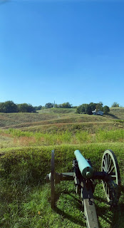
This is the field our guide was referring to. As we bus-toured the Vicksburg battlefield, our very knowledgeable guide paused at one point to help us imagine it as it was: Imagine a hilly-up-and-down field covering several football fields in length. You are told to charge (RUN!) from here to there in the sweltering July heat, carrying your nine pound rifle, being rather weak from too little food, and with iron balls fired from both sides raining down on you. The slaughter was horrible, “utter insanity,” said the guide.

(( TO BE CONTINUED))